 Doctor
Maritza ballester is one of the authors of the cuban forecasting model for
hurricane activity in the atlantic basin to be issued on May 2nd.
Doctor
Maritza ballester is one of the authors of the cuban forecasting model for
hurricane activity in the atlantic basin to be issued on May 2nd.Granma
March 30, 2000
Tropical
Hurricanes
One More Sleepless
Season?
ORFILIO
PELÁEZ
A CubaNews
translation. Edited by Walter Lippmann
http://www.granma.cubaweb.cu/secciones/ciencia/ciencia323.htm
The coming hurricane season will probably raise to nine the chain of consecutive years when the number of tropical hurricanes (with names) formed in the Atlantic basin has surpassed the average of 10 per year.
Doctor
Maritza ballester is one of the authors of the cuban forecasting model for
hurricane activity in the atlantic basin to be issued on May 2nd.
To support this view, Dr. Maritza Ballester, researcher of the Forecasting Center of the Meteorology Institute and a real authority on the subject, explained to Granma that all international forecasts indicate this season will again be very active with 15 to 17 tropical storms of which 8 or 9 can become hurricanes.
Several factors support this prediction. First, according to Dr. Ballester, most models show the prevalence of neutral conditions in the Eastern Equatorial Pacific Ocean during the next six months.
 Doctor
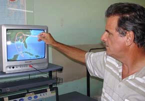
José Rubiera shows how the animated images of a hurricane’s TRAJECTORY CONE will
look on tv.
Doctor
José Rubiera shows how the animated images of a hurricane’s TRAJECTORY CONE will
look on tv.
At least for now, there is no indication of the development of an ENSO event (El Niño/Southern Oscillation) and this favors the formation of hurricanes in our geographical region.
At the end of February, the sea surface temperature in the Caribbean and the Mexican Gulf showed values slightly warmer than those for similar dates in 2005.
Such scenario propitiates an increased hurricane activity, also prodded by prevalence of favorable conditions for wind circulation in the lower stratosphere at heights from 21 to 24 kilometers.
Co-author of the Cuban Forecast Model for Tropical Hurricanes in the Northern Atlantic, with researcher Cecilia González and Doctor Ramón Pérez, Head of the Weather Center of the Meteorology Institute, Doctor Maritza Ballester explained that although the forecast will not be issued until May 2nd, a preliminary study shows the number of events with a name (they are given a name once they reach tropical storm intensities) could be around 15. Therefore, we share the views of American and British scientists.
All the above confirms once again that the region is going through a period of intense hurricane activity which started in 1995 and could expand to the next 15 or 20 years.
More evidence of this trend is the fact that since 1998 all eight seasons had a number of tropical hurricanes above historical averages, a fact never registered before in chronologies gathered since 1886.
When asked about similarities between the coming season and 2005 (which set all kinds of records including 27 tropical storms), Dr. Ballester explained that last year there was a process of cooling in the Equatorial Pacific Ocean near the South American coasts and this contributed to the increase of hurricane activity.
It seems such factor will not be in place this season. There was also a remarkable warming up of the sea surface in the entire Atlantic basin, with the highest values since the parameter was measured for the first time in 1951.
The 2005 season was news again after the final data analysis when its record of hurricanes was finally set on 15 (the previous record had been 12, set in 1969) after tropical storm Cindy was upgraded to the rank of hurricane and the record of category-5-hurricanes for one season rose to four when Emily was included in the list together with Katrina, Rita and Wilma.
ADJUSTING THE WHEELS
In view of the prospect of another summer with high occurrence of hurricanes in the North Atlantic, the Mexican Gulf and the Caribbean, Cuba readies its human and technological arsenals to deal with these disaster threats.
According to Dr. José Rubiera, Head of the Forecasts Department of the Meteorology Institute, the country will meet the 2006 hurricane season with the eight meteorological radars in the national net fully automated. This will allow for a real-time coverage of the trajectory and evolution of any tropical system threatening our archipelago.
The operational use of Model MM5, adapted to Cuban conditions by specialists from the Center of Physics of the Atmosphere in the same Institution, will become an additional tool to increase effectiveness in forecasting different hurricane variables.
Thanks to the new system for TV presentation of weather forecasts, in the event of a hurricane, viewers will be able to see animated trajectory cones, areas of influence and wind speeds, movements of associated rain nuclei, zones of most probable direct impact, coastal areas with probable occurrence of tidal waves or storm waves and other features for the better understanding of the characteristics of the phenomenon.
For everybody’s peace of mind, let it be said that Cuban meteorologists have readied their shields to face this new challenge of nature. Alberto could be the first of many battles.
Names for the hurricanes in 2006
Alberto, Beryl, Chris, Debby, Ernesto, Florence, Gordon, Helene, Isaac, Joyce, Kirk, Leslie, Michael, Nadine, Oscar, Patty, Rafael, Sandy, Tony, Valerie y William.
Number of tropical hurricanes with names in the last eight seasons
|
1998 |
14 |
|
1999 |
12 |
|
2000 |
14 |
|
2001 |
15 |
|
2002 |
12 |
|
2003 |
16 |
|
2004 |
16 |
|
2005 |
27 |